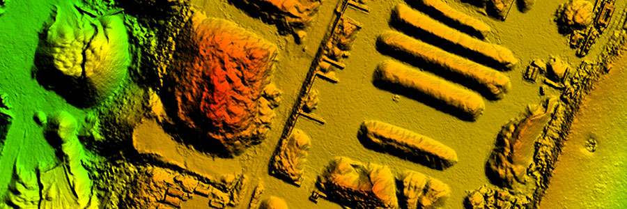
Volume Computations
Aerial Robotix is specialised in highly accurate surveys of stockpiles using to unmanned aerial vehicles(UAVs). Our UAVs are equipped with a high-resolution digital camera (36 Mp) that has been geometrically calibrated to perform measurements. The measurements are based on the principle of photogrammetry whereby terrain heights are extracted from a series of overlapping images.
This method gives a number of advantages over traditional (land based) survey methods:
- Safe: people are not required to climb on steep and unstable stockpile slopes
- Fast: we can measure up to 100 ha in one day of survey.
- Accurate: typical accuracies of 20 mm are obtained.
- Complete: the method yields over 100 measurements per square meter giving a complete image and thus more accurate results.
We can deliver the results in a number of ways. This ranges from a report indicating the volume of the stockpile to paper and or digital maps and 3D models of the stockpile. Typically half a day is required for the processing of all the survey results and the creation of a report.
Prior to the aerial survey ground control points are laid out in the vicinity of the stockpiles. These are then measured using RTK-GPS and used to obtain accurate end results. In addition a number of extra verification points are measured that are used to check the quality of the measurements.
Photographs are then taken of the stockpile using one of our small drones that is pre-programmed to follow a flight path and take the images at predefined locations. The location of the photographs is chosen such that a large overlap between the individual images is obtained.
The imagery is then processed using specialised software to create a point-cloud of all the measurements. Typically the software will create over 10 points per square meter depending on the size of the stockpile. This can be as much as 100 points per square meter for smaller areas.
The created point cloud is then checked using the extra control points that were measured by GPS prior to the aerial survey. The GPS points are then compared to the values of the computed point cloud and the quality is assessed.
The volume of a stockpile can be calculated from the 3D model of the stockpile that is created.